Introduction: From the ruggedness of the Rocky Mountains to the vastness of the Great Lakes, professional drones are redefining how data is collected from the North American terrain. For surveying engineers, infrastructure inspection teams, and emergency response crews, choosing a tool that can handle complex environments while delivering ultimate precision is crucial. The TX-C150G is not just another ordinary drone; it is an industrial-grade solution designed to meet the unique scale and challenges of the North American continent. This guide provides an in-depth analysis of how the TX-C150G, with its Vertical Take-Off and Landing (VTOL) capability, robust 8kg payload, and features tailored for the North American market, becomes the ace in the hands of professionals .
1. What is the Product? A Hybrid Power Solution Beyond Quadcopters
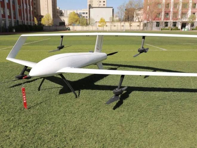
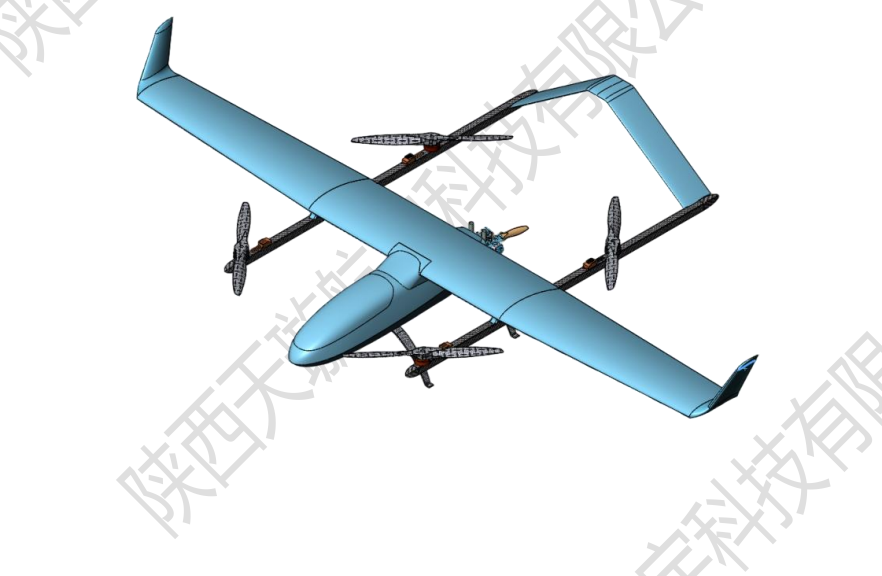
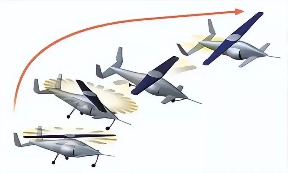
The TX-C150G is a Vertical Take-Off and Landing (VTOL) drone that combines a fixed-wing design with multi-rotor technology. This design allows it to harness the advantages of both: it can take off and land vertically like a multi-rotor craft, requiring no runway, and cruise with the efficiency and range of a fixed-wing aircraft .
This is immensely valuable for the vast, sparsely populated, and topographically varied regions of North America. Whether conducting geological surveys in the mountains of Alaska or monitoring crops on the sprawling farms of Texas, it can be deployed with ease, significantly enhancing field operation efficiency .
2. Core Features: Powerful Performance Born for Professional Applications
- Exceptional Payload and Endurance:
- 8kg Effective Payload: This enables it to carry various professional equipment, such as high-precision LiDAR, multispectral cameras, or large mapping cameras, far exceeding the load-bearing limits of consumer-grade drones .
- Long Flight Time: Combined with its aerodynamic design, it can provide several hours of endurance even when fully loaded, sufficient to cover large areas for mapping and inspection missions .
- Industrial-Grade Triple-Sensor Integrated Camera: Integrating visible light, thermal imaging, and laser rangefinding, its applications across North America are extensive :
- Infrastructure Inspection: Detecting hot spots on power transmission lines in Canada, assessing the structural integrity of bridges in California.
- Public Safety & Emergency Response: Providing thermal imaging maps of wildfires in Washington state forests, or locating missing persons during nighttime search and rescue operations.
- Solar Farm Inspection: Rapidly scanning large solar panel arrays in Arizona to accurately pinpoint faulty modules.
- High-Precision Navigation and Anti-Interference Capability: The built-in RTK module and anti-interference antennas ensure positioning accuracy in complex electromagnetic environments. This is crucial for North America’s increasingly crowded radio spectrum and for mapping projects requiring centimeter-level accuracy, such as urban modeling and engineering earthwork calculations .
3. Geographical Adaptability: Why the TX-C150G is Well-Suited for the North American Market
The North American market has unique demands for drones, and the TX-C150G’s design hits the mark .
- Regulatory Compliance: Its robust anti-interference and positioning capabilities help operators better comply with the strict regulations from the FAA and Transport Canada regarding flight safety and airspace management .
- Broad Application Scenarios:
- Energy Sector: Inspecting oil and gas pipelines spanning multiple states.
- Agriculture: Managing precision agriculture on thousands of acres of farms in the Midwest “Corn Belt”.
- Mining & Surveying: Conducting topographic mapping and volume measurements in remote mining areas of Northern Canada without deploying large ground survey teams .
- Environmental Adaptation: Its sturdy design can withstand harsh weather conditions common in North America, such as strong desert winds and low temperatures in mountainous areas, ensuring high mission success rates .
4. Pros and Cons Analysis
| Advantages | Disadvantages |
|---|---|
| ⛰️ Unmatched Terrain Adaptability: VTOL design allows takeoff/landing almost anywhere. | 💰 High Initial Investment: As industrial-grade equipment, its cost and supporting systems far exceed consumer drones. |
| 📦 Top-Tier Payload Flexibility: 8kg payload offers broad space for professional sensors. | 👨💻 Professional Operation Required: Requires trained professional pilots and mission planners; steep learning curve. |
| 🛰️ Excellent Data Accuracy: RTK and anti-jamming tech ensure data reliability in complex environments. | ⚖️ Size & Portability: Requires more planning for transport and deployment compared to smaller drones. |
| 🔋 Long Endurance & High Efficiency: Single flight covers larger areas, reducing per-unit area mapping costs. |
5. Competitive Analysis: Positioning in the North American Market
Within the North American industrial drone market, the TX-C150G’s main competitors include the DJI Matrice 350 RTK and the SenseFly eBee GEO .
- vs. DJI Matrice 350 RTK:
- TX-C150G Advantage: The hybrid power’s long endurance and efficiency in covering large areas are difficult for pure multi-rotor platforms to match. It is more efficient for wide-area mapping and linear infrastructure inspection.
- M350 RTK Advantage: DJI has a more mature software ecosystem and a strong brand channel with a broad user base and technical support network in North America.
- vs. SenseFly eBee GEO (Fixed-wing):
- TX-C150G Advantage: VTOL capability is a decisive advantage. The eBee GEO requires hand-launching or catapulting, needs specific launch sites, and cannot hover for detailed inspections. The TX-C150G offers more comprehensive application scenarios.
- eBee GEO Advantage: SenseFly has years of experience in pure fixed-wing drones, with excellent lightweight design and ease of use, enjoying a good reputation in traditional surveying.
Conclusion: The TX-C150G is a performance-oriented product for a niche market. Its unique VTOL design finds the optimal balance between versatility and operational efficiency, making it ideal for professional users with extreme demands for flight time and payload .
6. Case Study: TX-C150G in Action
Case 1: Power Line Inspection in the Colorado Mountains
- Challenge: Complex mountainous terrain, long line spans, making manual inspection dangerous and inefficient.
- Solution: An operations team used the TX-C150G equipped with LiDAR and a thermal imaging camera. It took off vertically from the mountain base, automatically cruised along the line, accurately identified several overheated insulator defects, and generated a high-precision 3D model of the line corridor.
- Value: Avoided the high cost of helicopter inspection, ensured personnel safety, and completed comprehensive digital archiving .
7. Conclusion
The TX-C150G VTOL drone is not merely an aircraft; it is a powerful aerial data acquisition platform. For professionals in surveying, inspection, security, and agriculture across North America, it represents an ultimate solution for enhancing efficiency, accuracy, and safety. Its value lies in its ability to go anywhere it’s needed and bring back the data you require .
If you are evaluating how to integrate drone technology into your North American operations, the TX-C150G is undoubtedly a strategic piece of equipment worth deep consideration.
Meta Description: Explore how the TX-C150G VTOL drone, with its 8kg payload, RTK accuracy, and long endurance, provides the ultimate solution for mapping, inspection, and agricultural applications in the North American market. In-depth review and localized insights.
Recommended Tags: Industrial VTOL Drone, North American Drone Mapping, TX-C150G Review, Long-Endurance Drone Inspection, Drone Payload Solution, FAA-Compliant Drone, Infrastructure Inspection Drone, Precision Agriculture Drone.